
Mapa topográfico Mittersill
Mapa interactivo
Haga clic en el mapa para ver la altitud.
Mittersill
It has traffic links running east to west and north to south. The Felbertauern road tunnel runs south through the Hohe Tauern at an elevation of about 1630 m, providing a connection with Lienz in East Tyrol. To the north lies the Thurn Pass at an elevation of 1274 m, providing a connection with Kitzbühel and Tyrol.
Acerca de este mapa
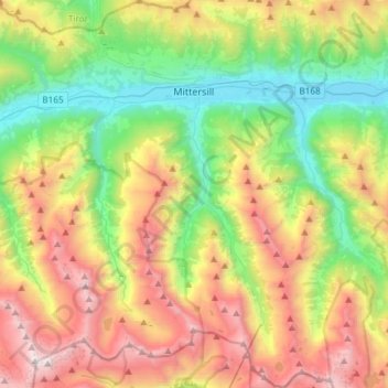
Nombre: Mapa topográfico Mittersill, altitud, relieve.
Lugar: Mittersill, Bezirk Zell am See, Salzburg, 5730, Austria (47.12761 12.37437 47.32862 12.56636)
Altitud media: 1.729 m
Altitud mínima: 769 m
Altitud máxima: 3.213 m