
Mapa topográfico Burnt Pond
Mapa interactivo
Haga clic en el mapa para ver la altitud.
Acerca de este mapa
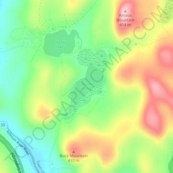
Nombre: Mapa topográfico Burnt Pond, altitud, relieve.
Altitud media: 324 m
Altitud mínima: 232 m
Altitud máxima: 442 m
Otros mapas topográficos
Haga clic en un mapa para ver su topografía, su altitud y su relieve.
Silver Bay
United States > New York > Warren County
Silver Bay, Town of Hague, Warren County, New York, 12874, United States
Altitud media: 218 m
Height of Land Mountain
United States > New York > Warren County > Town of Johnsburg
Height of Land Mountain, Town of Johnsburg, Warren County, New York, United States
Altitud media: 759 m
Diamond Point (hamlet)
United States > New York > Warren County > Town of Lake George
Diamond Point (hamlet), Town of Lake George, Warren County, New York, 12824, United States
Altitud media: 191 m
Town of Bolton
United States > New York > Warren County
Town of Bolton, Warren County, New York, United States
Altitud media: 297 m
Lake George
United States > New York > Warren County > Town of Bolton
Lake George, Town of Bolton, Warren County, New York, United States
Altitud media: 247 m