
Haz una donación
Mapa topográfico Chimacum
Haga clic en el mapa para ver la altitud.
Haz una donación
Acerca de este mapa
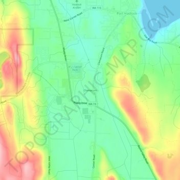
Nombre: Mapa topográfico Chimacum, altitud, relieve.
Altitud media: 59 m
Altitud mínima: -1 m
Altitud máxima: 154 m
Haz una donación
Otros mapas topográficos
Haga clic en un mapa para ver su topografía, su altitud y su relieve.
Hoh River
United States > Washington > Jefferson County
The Hoh River Trail, managed by the National Park Service, begins at the national park's Hoh Rain Forest Visitor Center at the end of the Upper Hoh Road. The trail follows the Hoh River east into the heart of the park. After 17.5 mi (28.2 km) it reaches Glacier Meadows near Mount Olympus's Blue Glacier. The…
Altitud media: 534 m
Haz una donación
Haz una donación
Hoh River
United States > Washington > Jefferson County
The Hoh River Trail, managed by the National Park Service, begins at the national park's Hoh Rain Forest Visitor Center at the end of the Upper Hoh Road. The trail follows the Hoh River east into the heart of the park. After 17.5 mi (28.2 km) it reaches Glacier Meadows near Mount Olympus's Blue Glacier. The…
Altitud media: 531 m
Haz una donación
Haz una donación