
Mapa topográfico Schmidmühlen
Mapa interactivo
Haga clic en el mapa para ver la altitud.
Acerca de este mapa
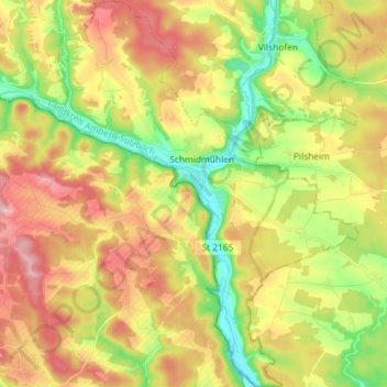
Nombre: Mapa topográfico Schmidmühlen, altitud, relieve.
Altitud media: 431 m
Altitud mínima: 347 m
Altitud máxima: 518 m
Otros mapas topográficos
Haga clic en un mapa para ver su topografía, su altitud y su relieve.
Schnaittenbach
Germany > Bavaria > Landkreis Amberg-Sulzbach
Schnaittenbach, Landkreis Amberg-Sulzbach, Bavaria, 92253, Germany
Altitud media: 480 m
Pursruck
Germany > Bavaria > Landkreis Amberg-Sulzbach
Pursruck, Freudenberg, Landkreis Amberg-Sulzbach, Bavaria, 92272, Germany
Altitud media: 496 m
Schmelzmühle
Germany > Bavaria > Landkreis Amberg-Sulzbach > Freihung
Schmelzmühle, Freihung, Landkreis Amberg-Sulzbach, Bavaria, 92271, Germany
Altitud media: 427 m
Bergstein
Germany > Bavaria > Landkreis Amberg-Sulzbach > Illschwang
Bergstein, Illschwang, Illschwang (VGem), Landkreis Amberg-Sulzbach, Bavaria, 92278, Germany
Altitud media: 548 m
Vilseck
Germany > Bavaria > Landkreis Amberg-Sulzbach
Vilseck, Landkreis Amberg-Sulzbach, Bavaria, 92249, Germany
Altitud media: 443 m