
Haz una donación
Mapa topográfico Berwick-upon-Tweed
Haga clic en el mapa para ver la altitud.
Haz una donación
Berwick-upon-Tweed
In the 1840s, Samuel Lewis included similar entries for Berwick-upon-Tweed in both his England and Scotland Topographical Dictionary. Berwick remained a county in its own right, and remained a separate parliamentary constituency until 1885 when it was merged to become a division of Northumberland under the Redistribution of Seats Act 1885. In 1889 elected county councils were established under the Local Government Act 1888, which were based on the parliamentary boundaries of counties, and so Berwick was brought under the jurisdiction of Northumberland County Council, with the town council thereafter being a lower-tier authority subordinate to the county council.
Haz una donación
Acerca de este mapa
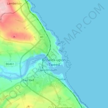
Nombre: Mapa topográfico Berwick-upon-Tweed, altitud, relieve.
Altitud media: 33 m
Altitud mínima: -1 m
Altitud máxima: 197 m
Haz una donación
Otros mapas topográficos
Haga clic en un mapa para ver su topografía, su altitud y su relieve.
Catcleugh Reservoir
United Kingdom > England > Northumberland
Catcleugh Reservoir is a reservoir in Northumberland, England, adjacent to the A68 road just north of Byrness and to the southeast of the border with Scotland. It has a surface area of 98.654 ha and a mean depth of 9.8 m, a catchment area of 4007.5 ha, and is situated at 247 m altitude.
Altitud media: 316 m
Haz una donación
Haz una donación
Haz una donación
Haz una donación
Amble
United Kingdom > England > Northumberland
Samuel Lewis reported a township population of 247 in 1831. By the seventh edition of his Topographical Dictionary of England, which was published in 1848, this figure had risen to 724. The population was reported as being 1,040 in 1851. The 1871 census recorded a population of 1,233, spread among 233 houses.
Altitud media: 15 m
Haz una donación
Haz una donación
Haz una donación
Haz una donación
Sharp Law
United Kingdom > England > Northumberland > Crookham > Crookham Eastfield
Altitud media: 56 m
Haz una donación
Haz una donación
Haz una donación
Haz una donación
Haz una donación
Haz una donación
Haz una donación
Haz una donación
Haz una donación
Haz una donación
Haz una donación
Haz una donación
Haz una donación
Haz una donación
Haz una donación
Haz una donación
Haz una donación