
Mapa topográfico Holly
Mapa interactivo
Haga clic en el mapa para ver la altitud.
Acerca de este mapa
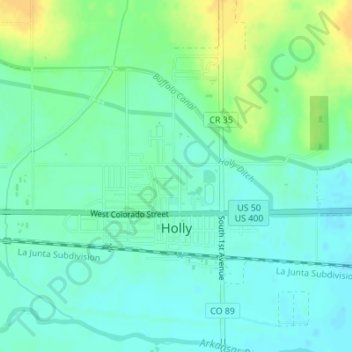
Nombre: Mapa topográfico Holly, altitud, relieve.
Lugar: Holly, Prowers County, Colorado, United States (38.04797 -102.13271 38.06447 -102.11864)
Altitud media: 1.037 m
Altitud mínima: 1.028 m
Altitud máxima: 1.053 m
Holly is a statutory town in Prowers County in southeastern Colorado, United States. The town is located 4.3 miles (6.9 km) west of the Kansas border at an elevation of 3,393 feet (1,034 m). Despite having the lowest elevation of any Colorado municipality, Holly is higher than the high points of 19 states and the District of Columbia. The town population was 837 at the 2020 United States Census.
Otros mapas topográficos
Haga clic en un mapa para ver su topografía, su altitud y su relieve.
Lamar
United States > Colorado > Prowers County
Lamar, Prowers County, Colorado, 81052, United States
Altitud media: 1.118 m