
Mapa topográfico Tirur
Mapa interactivo
Haga clic en el mapa para ver la altitud.
Acerca de este mapa
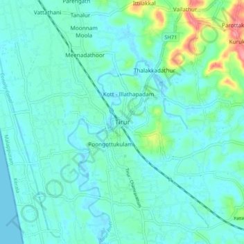
Nombre: Mapa topográfico Tirur, altitud, relieve.
Lugar: Tirur, Malappuram, Kerala, 676101, India (10.87676 75.88395 10.95676 75.96395)
Altitud media: 15 m
Altitud mínima: -2 m
Altitud máxima: 88 m
Tirur is a Town and municipality in Malappuram district in the Indian state of Kerala spread over an area of 62.34 square kilometres (24.07 sq mi). It is one of the business centers of Malappuram district and is situated 26 kilometres (16 mi) west of Malappuram and 52.5 kilometres (32.6 mi) south of Kozhikode, on the Shoranur–Mangalore section of the Mangalore–Chennai railway line. Tirur is also a major regional trading centre for fish and betel leaf and has an average elevation of 2 metres (6 ft 7 in).