
Haz una donación
Mapa topográfico Kremna
Haga clic en el mapa para ver la altitud.
Haz una donación
Acerca de este mapa
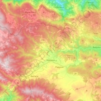
Nombre: Mapa topográfico Kremna, altitud, relieve.
Altitud media: 880 m
Altitud mínima: 393 m
Altitud máxima: 1.249 m
Haz una donación
Otros mapas topográficos
Haga clic en un mapa para ver su topografía, su altitud y su relieve.
Tara
Serbia > Central Serbia > Zlatibor Administrative District > Uzice
Tara (Serbian Cyrillic: Тара, pronounced [târa]) is a mountain in western Serbia. It is part of the Dinaric Alps and stands at 1,000 to 1,590 m (3,280 to 5,220 ft) above sea level. The mountain's slopes are clad in dense forests with numerous high-elevation clearings and meadows, steep cliffs, deep…
Altitud media: 1.325 m
Haz una donación