
Haz una donación
Mapa topográfico Gopeshwar
Haga clic en el mapa para ver la altitud.
Haz una donación
Gopeshwar
Gopeshwar is located at 30°25′N 79°20′E / 30.42°N 79.33°E / 30.42; 79.33. It has an average elevation of 1,450 m (4,760 ft). Gopeshwar is 8.4 km (5.2 mi) away from Chamoli which is located on the banks of Alaknanda river and along NH 58.
Haz una donación
Acerca de este mapa
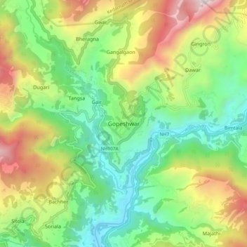
Nombre: Mapa topográfico Gopeshwar, altitud, relieve.
Lugar: Gopeshwar, Chamoli Tehsil, Chamoli, Uttarakhand, 246401, India (30.36878 79.27855 30.44878 79.35855)
Altitud media: 1.566 m
Altitud mínima: 895 m
Altitud máxima: 2.725 m
Haz una donación
Otros mapas topográficos
Haga clic en un mapa para ver su topografía, su altitud y su relieve.
Roopkund Lake
India > Uttarakhand > Chamoli Tehsil
Roopkund (locally known as Mystery Lake or Skeleton Lake) is a high altitude glacial lake in the Uttarakhand state of India. It lies in the lap of Trishul massif. Located in the Himalayas, the area around the lake is uninhabited and is roughly at an altitude of 5,020 metres (16,470 ft), surrounded by…
Altitud media: 4.631 m