
Mapa topográfico Teresina
Mapa interactivo
Haga clic en el mapa para ver la altitud.
Acerca de este mapa
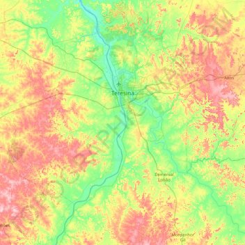
Nombre: Mapa topográfico Teresina, altitud, relieve.
Altitud media: 134 m
Altitud mínima: 43 m
Altitud máxima: 288 m
Teresina is located on the east side of the Parnaíba river at the border with Maranhão state, at an altitude of about 72 meters. The city faces the city of Timon across the river and is situated between the Parnaíba river and its tributary the Poti River. The two rivers join at the city's northern end, where there is an environmental park with gazebos. Teresina is the largest capital in the northeastern territorial extension, at 1,756 km2.
Otros mapas topográficos
Haga clic en un mapa para ver su topografía, su altitud y su relieve.
Altos
Brazil > Piauí > Região Integrada de Desenvolvimento da Grande Teresina
Altos, Região Geográfica Imediata de Teresina, Região Integrada de Desenvolvimento da Grande Teresina, Região Geográfica Intermediária de Teresina, Piauí, Northeast Region, 64290-000, Brazil
Altitud media: 161 m
Beneditinos
Brazil > Piauí > Região Integrada de Desenvolvimento da Grande Teresina
Beneditinos, Região Geográfica Imediata de Teresina, Região Integrada de Desenvolvimento da Grande Teresina, Região Geográfica Intermediária de Teresina, Piauí, Northeast Region, 64380-000, Brazil
Altitud media: 135 m
União
Brazil > Piauí > Região Integrada de Desenvolvimento da Grande Teresina
União, Região Geográfica Imediata de Teresina, Região Integrada de Desenvolvimento da Grande Teresina, Região Geográfica Intermediária de Teresina, Piauí, Northeast Region, 64120-000, Brazil
Altitud media: 97 m