
Gracias por apoyar a este sitio ❤️
Haz una donación
Haz una donación
Mapa topográfico Lake Oconee
Haga clic en el mapa para ver la altitud.
Gracias por apoyar a este sitio ❤️
Haz una donación
Haz una donación
Acerca de este mapa
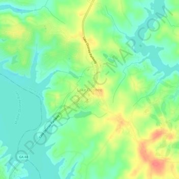
Nombre: Mapa topográfico Lake Oconee, altitud, relieve.
Lugar: Lake Oconee, Greene County, Georgia, USA (33.43830 -83.26396 33.47830 -83.22396)
Altitud media: 151 m
Altitud mínima: 128 m
Altitud máxima: 188 m
Gracias por apoyar a este sitio ❤️
Haz una donación
Haz una donación