
Mapa topográfico Le Plan
Mapa interactivo
Haga clic en el mapa para ver la altitud.
Acerca de este mapa
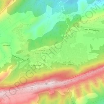
Nombre: Mapa topográfico Le Plan, altitud, relieve.
Altitud media: 720 m
Altitud mínima: 462 m
Altitud máxima: 1.032 m
Otros mapas topográficos
Haga clic en un mapa para ver su topografía, su altitud y su relieve.
Saint-Pilon
France > Provence-Alpes-Côte d'Azur > Var > Plan-d'Aups-Sainte-Baume
Saint-Pilon, Plan-d'Aups-Sainte-Baume, Brignoles, Var, Provence-Alpes-Côte d'Azur, France métropolitaine, 83640, France
Altitud media: 764 m
Le Corps-de-Ville
France > Provence-Alpes-Côte d'Azur > Var > Plan-d'Aups-Sainte-Baume
Le Corps-de-Ville, Plan-d'Aups-Sainte-Baume, Brignoles, Var, Provence-Alpes-Côte d'Azur, France métropolitaine, 83640, France
Altitud media: 728 m
Sainte-Madeleine
France > Provence-Alpes-Côte d'Azur > Var > Plan-d'Aups-Sainte-Baume
Sainte-Madeleine, Plan-d'Aups-Sainte-Baume, Brignoles, Var, Provence-Alpes-Côte d'Azur, France métropolitaine, 83640, France
Altitud media: 741 m
Valentine
France > Provence-Alpes-Côte d'Azur > Var > Plan-d'Aups-Sainte-Baume
Valentine, Plan-d'Aups-Sainte-Baume, Brignoles, Var, Provence-Alpes-Côte d'Azur, France métropolitaine, 83640, France
Altitud media: 688 m
Réserve biologique dirigée de Sainte-Baume
France > Provence-Alpes-Côte d'Azur > Var > Plan-d'Aups-Sainte-Baume
Réserve biologique dirigée de Sainte-Baume, La Voie Royale, Plan-d'Aups-Sainte-Baume, Brignoles, Var, Provence-Alpes-Côte d'Azur, France métropolitaine, 83640, France
Altitud media: 757 m
Saint-Victor
France > Provence-Alpes-Côte d'Azur > Var > Plan-d'Aups-Sainte-Baume
Saint-Victor, Plan-d'Aups-Sainte-Baume, Brignoles, Var, Provence-Alpes-Côte d'Azur, France métropolitaine, 83640, France
Altitud media: 736 m