
Mapa topográfico Asclepion
Mapa interactivo
Haga clic en el mapa para ver la altitud.
Acerca de este mapa
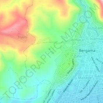
Nombre: Mapa topográfico Asclepion, altitud, relieve.
Altitud media: 125 m
Altitud mínima: 41 m
Altitud máxima: 300 m
In the late 18th century, these visits were reinforced by a scholarly (especially ancient historical) desire for research, epitomised by Marie-Gabriel-Florent-Auguste de Choiseul-Gouffier, a traveller in Asia Minor and French ambassador to the Sublime Porte in Istanbul from 1784 to 1791. At the beginning of the 19th century, Charles Robert Cockerell produced a detailed account and Otto Magnus von Stackelberg made important sketches. A proper, multi-page description with plans, elevations, and views of the city and its ruins was first produced by Charles Texier when he published the second volume of his Description de l’Asie mineure.
Otros mapas topográficos
Haga clic en un mapa para ver su topografía, su altitud y su relieve.
Talatpaşa Mahallesi
Talatpaşa Mahallesi, Bergama, Izmir, Aegean Region, Turkey
Altitud media: 112 m
Gazipaşa Mahallesi
Gazipaşa Mahallesi, Bergama, Izmir, Aegean Region, Turkey
Altitud media: 102 m
İnkılap Mahallesi
İnkılap Mahallesi, Bergama, Izmir, Aegean Region, Turkey
Altitud media: 79 m