
Gracias por apoyar a este sitio ❤️
Haz una donación
Haz una donación
Mapa topográfico Wading River
Haga clic en el mapa para ver la altitud.
Gracias por apoyar a este sitio ❤️
Haz una donación
Haz una donación
Wading River
The earliest English records show a settlement known as Wading River was founded by eight colonial families. "The spot for the village was chosen with care. There was a stream adequate for water power and abounding in seafood...good water for drinking...soil rich enough to grow essential crops, woodland for fuel, building material and food, topography to offer protection from the elements, meadowland for its grass."
Gracias por apoyar a este sitio ❤️
Haz una donación
Haz una donación
Acerca de este mapa
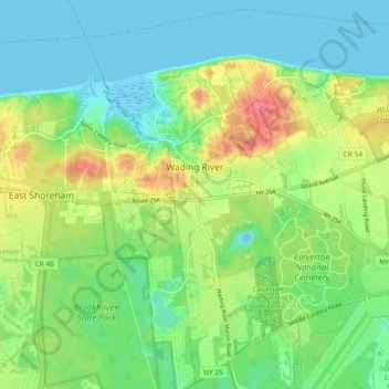
Nombre: Mapa topográfico Wading River, altitud, relieve.
Altitud media: 23 m
Altitud mínima: -4 m
Altitud máxima: 66 m
Gracias por apoyar a este sitio ❤️
Haz una donación
Haz una donación
Otros mapas topográficos
Haga clic en un mapa para ver su topografía, su altitud y su relieve.