
Mapa topográfico Winlock
Mapa interactivo
Haga clic en el mapa para ver la altitud.
Acerca de este mapa
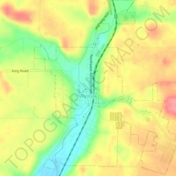
Nombre: Mapa topográfico Winlock, altitud, relieve.
Lugar: Winlock, Lewis County, Washington, United States (46.48013 -122.95086 46.50712 -122.91892)
Altitud media: 124 m
Altitud mínima: 78 m
Altitud máxima: 162 m
The eastern edge of the Willapa Hills lie to the west. To the east are relatively flat prairies. A notable landmark about four miles west of town is Sam Henry Mountain, elevation 1,492 feet (455 m), named for an early section superintendent of the Northern Pacific Railroad. Mt. St. Helens, about forty miles (64.4 km) to the east can be seen from viewpoints around the area. In May 1980, Winlock was covered with about one inch (2.54 cm) of volcanic ash from the second major eruption of this peak one week after the cataclysmic eruption of May 18.
Otros mapas topográficos
Haga clic en un mapa para ver su topografía, su altitud y su relieve.
Cinebar
United States > Washington > Lewis County
Cinebar, Lewis County, Washington, 98533, United States
Altitud media: 308 m
Narada Falls
United States > Washington > Lewis County
Narada Falls, Lewis County, Washington, United States
Altitud media: 1.444 m
Fords Prairie
United States > Washington > Lewis County
Fords Prairie, Lewis County, Washington, United States
Altitud media: 67 m
Bremer
United States > Washington > Lewis County
Bremer, Lewis County, Washington, United States
Altitud media: 430 m
Walupt Creek Falls
United States > Washington > Lewis County
Walupt Creek Falls, Lewis County, Washington, United States
Altitud media: 1.158 m
Centralia
United States > Washington > Lewis County
Centralia, Lewis County, Washington, United States
Altitud media: 74 m
Napavine
United States > Washington > Lewis County
Napavine, Lewis County, Washington, 98565, United States
Altitud media: 105 m
Adna
United States > Washington > Lewis County
Adna, Lewis County, Washington, United States
Altitud media: 82 m
Chehalis
United States > Washington > Lewis County
Chehalis, Lewis County, Washington, United States
Altitud media: 81 m
Chimney Rock
United States > Washington > Lewis County
Chimney Rock, Lewis County, Washington, United States
Altitud media: 1.593 m
Glenoma
United States > Washington > Lewis County
Glenoma, Lewis County, Washington, 98336, United States
Altitud media: 354 m
Vader
United States > Washington > Lewis County
Vader, Lewis County, Washington, 98593, United States
Altitud media: 74 m
Morton
United States > Washington > Lewis County
Morton, Lewis County, Washington, United States
Altitud media: 328 m
Onalaska
United States > Washington > Lewis County
Onalaska, Lewis County, Washington, 98570, United States
Altitud media: 170 m
Mossyrock
United States > Washington > Lewis County > Mossyrock
Mossyrock, Lewis County, Washington, 98564, United States
Altitud media: 213 m
Mineral
United States > Washington > Lewis County > Mineral
Mineral, Lewis County, Washington, 98355, United States
Altitud media: 481 m
Randle
United States > Washington > Lewis County
Randle, Lewis County, Washington, United States
Altitud media: 378 m
Packwood
United States > Washington > Lewis County
Packwood, Lewis County, Washington, United States
Altitud media: 379 m