
Mapa topográfico Rockvale Township
Mapa interactivo
Haga clic en el mapa para ver la altitud.
Acerca de este mapa
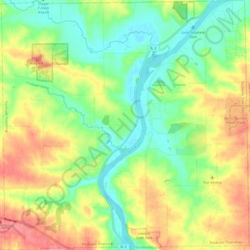
Nombre: Mapa topográfico Rockvale Township, altitud, relieve.
Lugar: Rockvale Township, Ogle County, Illinois, United States (42.02829 -89.39417 42.11656 -89.27627)
Altitud media: 239 m
Altitud mínima: 204 m
Altitud máxima: 286 m
Otros mapas topográficos
Haga clic en un mapa para ver su topografía, su altitud y su relieve.
Grand Detour
United States > Illinois > Ogle County
Grand Detour, Grand Detour Township, Ogle County, Illinois, United States
Altitud media: 213 m
Oregon
United States > Illinois > Ogle County
Oregon, Oregon - Nashua Township, Ogle County, Illinois, 61061, United States
Altitud media: 223 m
Stillman Valley
United States > Illinois > Ogle County
Stillman Valley, Marion Township, Ogle County, Illinois, United States
Altitud media: 222 m
Lost Nation
United States > Illinois > Ogle County
Lost Nation, Taylor Township, Ogle County, Illinois, United States
Altitud media: 223 m
Leaf River
United States > Illinois > Ogle County
Leaf River, Leaf River Township, Ogle County, Illinois, United States
Altitud media: 227 m
Monroe Township
United States > Illinois > Ogle County
Monroe Township, Ogle County, Illinois, 61052, United States
Altitud media: 243 m
Byron
United States > Illinois > Ogle County > Byron
Byron, Ogle County, Illinois, 61010, United States
Altitud media: 226 m
Monroe Center
United States > Illinois > Ogle County
Monroe Center, Monroe Township, Ogle County, Illinois, United States
Altitud media: 254 m
Rochelle
United States > Illinois > Ogle County
Rochelle, Flagg Township, Ogle County, Illinois, 61068, United States
Altitud media: 243 m