
Mapa topográfico Bollitree Castle
Mapa interactivo
Haga clic en el mapa para ver la altitud.
Acerca de este mapa
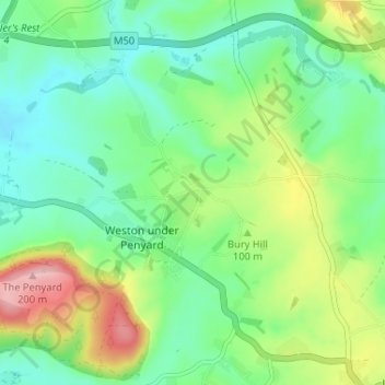
Nombre: Mapa topográfico Bollitree Castle, altitud, relieve.
Altitud media: 87 m
Altitud mínima: 34 m
Altitud máxima: 199 m
Otros mapas topográficos
Haga clic en un mapa para ver su topografía, su altitud y su relieve.
Kingstone
United Kingdom > England > Herefordshire > Weston under Penyard
Kingstone, Weston under Penyard, Herefordshire, England, HR9 7PH, United Kingdom
Altitud media: 83 m
Weston under Penyard
United Kingdom > England > Herefordshire > Weston under Penyard
Weston under Penyard, Herefordshire, West Midlands, England, United Kingdom
Altitud media: 98 m