
Gracias por apoyar a este sitio ❤️
Haz una donación
Haz una donación
Mapa topográfico Ness
Haga clic en el mapa para ver la altitud.
Gracias por apoyar a este sitio ❤️
Haz una donación
Haz una donación
Acerca de este mapa
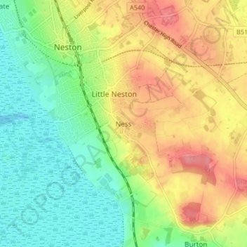
Nombre: Mapa topográfico Ness, altitud, relieve.
Altitud media: 34 m
Altitud mínima: -1 m
Altitud máxima: 75 m
Gracias por apoyar a este sitio ❤️
Haz una donación
Haz una donación
Otros mapas topográficos
Haga clic en un mapa para ver su topografía, su altitud y su relieve.
Wirral Country Park
United Kingdom > England > Cheshire West and Chester > Neston > Windle Hill
Altitud media: 49 m