
Gracias por apoyar a este sitio ❤️
Haz una donación
Haz una donación
Mapa topográfico Manton
Haga clic en el mapa para ver la altitud.
Gracias por apoyar a este sitio ❤️
Haz una donación
Haz una donación
Acerca de este mapa
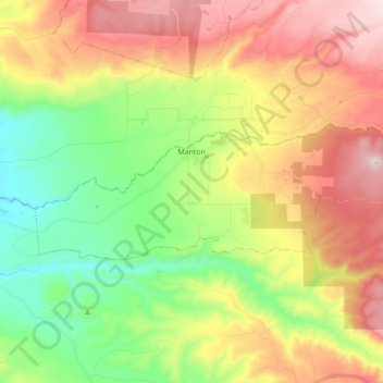
Nombre: Mapa topográfico Manton, altitud, relieve.
Lugar: Manton, Tehama County, California, United States (40.39779 -121.94115 40.44498 -121.76692)
Altitud media: 722 m
Altitud mínima: 352 m
Altitud máxima: 1.207 m
Gracias por apoyar a este sitio ❤️
Haz una donación
Haz una donación
Otros mapas topográficos
Haga clic en un mapa para ver su topografía, su altitud y su relieve.
Paskenta
United States > California > Tehama County
Paskenta (Wintun: Paskenti) is a small unincorporated town in Tehama County, California. Historically, it had greater local importance due to the presence of an active lumber mill. The ZIP Code is 96074. The community is inside area code 530 and the Paskenta CDP. Paskenta sits at an elevation of 725 feet (221…
Altitud media: 268 m
Gracias por apoyar a este sitio ❤️
Haz una donación
Haz una donación