
Mapa topográfico Toutle River Sediment Retention Structure
Mapa interactivo
Haga clic en el mapa para ver la altitud.
Acerca de este mapa
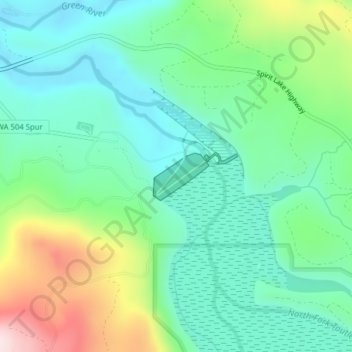
Nombre: Mapa topográfico Toutle River Sediment Retention Structure, altitud, relieve.
Altitud media: 347 m
Altitud mínima: 223 m
Altitud máxima: 654 m
Otros mapas topográficos
Haga clic en un mapa para ver su topografía, su altitud y su relieve.
Ryderwood
United States > Washington > Cowlitz County
Ryderwood, Cowlitz County, Washington, 98581, United States
Altitud media: 158 m
Kalama
United States > Washington > Cowlitz County
Kalama, Cowlitz County, Washington, 98625, United States
Altitud media: 58 m
Ariel
United States > Washington > Cowlitz County
Ariel, Cowlitz County, Washington, United States
Altitud media: 206 m
Woodland
United States > Washington > Cowlitz County
Woodland, Cowlitz County, Washington, 98674, United States
Altitud media: 36 m
Yale
United States > Washington > Cowlitz County
Yale, Cowlitz County, Washington, 98603, United States
Altitud media: 257 m
Castle Rock
United States > Washington > Cowlitz County
Castle Rock, Cowlitz County, Washington, 98611, United States
Altitud media: 55 m
Cougar
United States > Washington > Cowlitz County
Cougar, Cowlitz County, Washington, 98616, United States
Altitud media: 311 m
Kelso
United States > Washington > Cowlitz County
Kelso, Cowlitz County, Washington, 98626, United States
Altitud media: 52 m