
Haz una donación
Mapa topográfico Huddleston
Haga clic en el mapa para ver la altitud.
Haz una donación
Acerca de este mapa
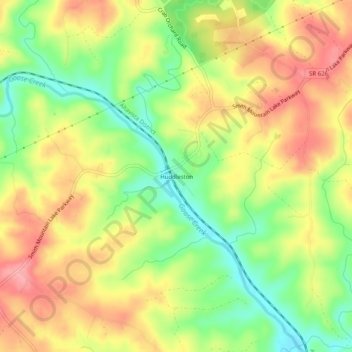
Nombre: Mapa topográfico Huddleston, altitud, relieve.
Lugar: Huddleston, Bedford County, Virginia, United States (37.13681 -79.49447 37.17681 -79.45447)
Altitud media: 226 m
Altitud mínima: 171 m
Altitud máxima: 276 m
Haz una donación
Otros mapas topográficos
Haga clic en un mapa para ver su topografía, su altitud y su relieve.
Haz una donación
Blue Ridge Mountains
United States > Virginia > Bedford County
Although the term "Blue Ridge" is sometimes applied exclusively to the eastern edge or front range of the Appalachian Mountains, the geological definition of the Blue Ridge province extends westward to the Ridge and Valley area, encompassing the Great Smoky Mountains, the Great Balsams, the Roans, the Blacks,…
Altitud media: 548 m
Haz una donación