
Gracias por apoyar a este sitio ❤️
Haz una donación
Haz una donación
Mapa topográfico The Farm
Haga clic en el mapa para ver la altitud.
Gracias por apoyar a este sitio ❤️
Haz una donación
Haz una donación
Acerca de este mapa
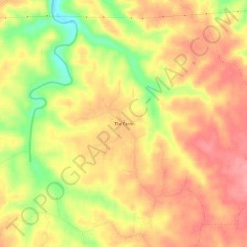
Nombre: Mapa topográfico The Farm, altitud, relieve.
Lugar: The Farm, Lewis County, Tennessee, United States (35.46773 -87.35668 35.50773 -87.31668)
Altitud media: 288 m
Altitud mínima: 227 m
Altitud máxima: 322 m
Gracias por apoyar a este sitio ❤️
Haz una donación
Haz una donación
Otros mapas topográficos
Haga clic en un mapa para ver su topografía, su altitud y su relieve.