
Gracias por apoyar a este sitio ❤️
Haz una donación
Haz una donación
Mapa topográfico Bermuda Dunes
Haga clic en el mapa para ver la altitud.
Gracias por apoyar a este sitio ❤️
Haz una donación
Haz una donación
Bermuda Dunes
According to the United States Census Bureau, the CDP has a total area of 2.9 square miles (7.5 km2), all of it land. The official elevation of Bermuda Dunes is 30 feet (9.1 m) above sea level, but the surface drops by over 80 feet (24 m) from west to east.
Gracias por apoyar a este sitio ❤️
Haz una donación
Haz una donación
Acerca de este mapa
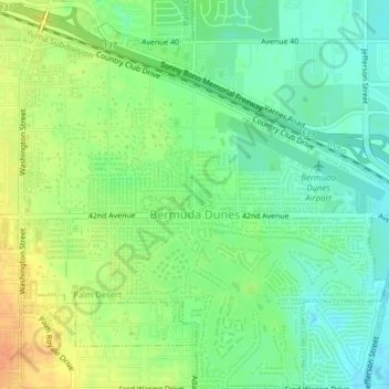
Nombre: Mapa topográfico Bermuda Dunes, altitud, relieve.
Altitud media: 27 m
Altitud mínima: 11 m
Altitud máxima: 48 m
Gracias por apoyar a este sitio ❤️
Haz una donación
Haz una donación
Otros mapas topográficos
Haga clic en un mapa para ver su topografía, su altitud y su relieve.