
Mapa topográfico Apirede
Mapa interactivo
Haga clic en el mapa para ver la altitud.
Acerca de este mapa
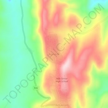
Nombre: Mapa topográfico Apirede, altitud, relieve.
Lugar: Apirede, Okere District, Eastern Region, Ghana (6.01537 -0.09963 6.05537 -0.05963)
Altitud media: 342 m
Altitud mínima: 180 m
Altitud máxima: 513 m
Otros mapas topográficos
Haga clic en un mapa para ver su topografía, su altitud y su relieve.
Lakpa
Ghana > Eastern Region > Okere District
Lakpa, Okere District, Eastern Region, Ghana
Altitud media: 191 m
Adukrom
Ghana > Eastern Region > Okere District
Adukrom, Okere District, Eastern Region, Ghana
Altitud media: 304 m