
Haz una donación
Mapa topográfico Snake Indian Falls
Haga clic en el mapa para ver la altitud.
Haz una donación
Acerca de este mapa
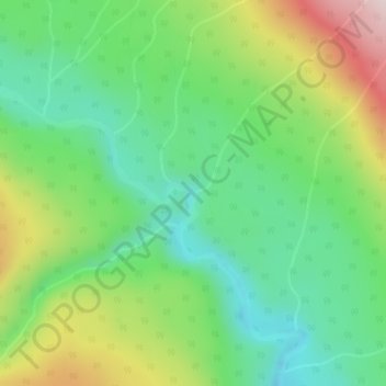
Nombre: Mapa topográfico Snake Indian Falls, altitud, relieve.
Altitud media: 1.367 m
Altitud mínima: 1.230 m
Altitud máxima: 1.615 m
Haz una donación
Otros mapas topográficos
Haga clic en un mapa para ver su topografía, su altitud y su relieve.
Maligne Lake
Canada > Alberta > Improvement District No. 12
Wildlife is surprisingly abundant along this high altitude oligotrophic lake. Grizzly bear, black bear, mule deer, caribou, wolves, moose, and mountain sheep are some of the larger mammals that frequent the lake area during the summer season. Bald eagles, golden eagles and osprey also frequent the area and…
Altitud media: 2.125 m
Haz una donación
Lawrence Glacier
Canada > Alberta > Improvement District No. 12 > Area A (Kicking Horse/Kinbasket Lake)
Altitud media: 2.619 m
Maligne Lake
Canada > Alberta > Improvement District No. 12
Wildlife is surprisingly abundant along this high altitude oligotrophic lake. Grizzly bear, black bear, mule deer, caribou, wolves, moose, and mountain sheep are some of the larger mammals that frequent the lake area during the summer season. Bald eagles, golden eagles and osprey also frequent the area and…
Altitud media: 2.125 m
Haz una donación