
Gracias por apoyar a este sitio ❤️
Haz una donación
Haz una donación
Mapa topográfico Guntur
Haga clic en el mapa para ver la altitud.
Gracias por apoyar a este sitio ❤️
Haz una donación
Haz una donación
Guntur
Guntur is located at 16°17′N 80°26′E / 16.29°N 80.43°E / 16.29; 80.43. It has an average elevation of 33 metres (108 ft) and is situated on the plains. There are few hills in the surrounding suburban areas and Perecherla Reserve Forest is located in the city's north-west. Guntur lies approximately 30 kilometres (19 mi) south of Amaravati, the capital of Andhra Pradesh.
Gracias por apoyar a este sitio ❤️
Haz una donación
Haz una donación
Acerca de este mapa
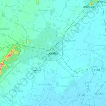
Nombre: Mapa topográfico Guntur, altitud, relieve.
Lugar: Guntur, Andhra Pradesh, 522001, India (16.13152 80.29416 16.45152 80.61416)
Altitud media: 29 m
Altitud mínima: 6 m
Altitud máxima: 474 m
Gracias por apoyar a este sitio ❤️
Haz una donación
Haz una donación
Otros mapas topográficos
Haga clic en un mapa para ver su topografía, su altitud y su relieve.