
Mapa topográfico Truro
Mapa interactivo
Haga clic en el mapa para ver la altitud.
Acerca de este mapa
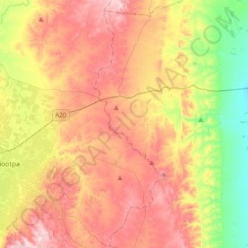
Nombre: Mapa topográfico Truro, altitud, relieve.
Altitud media: 320 m
Altitud mínima: 121 m
Altitud máxima: 518 m
Truro (postcode 5356, altitude 311m) is a town in South Australia, 80 km northeast of Adelaide. It is situated in an agricultural and pastoral district on the Sturt Highway, east of the Barossa Valley, where the highway crosses somewhat lofty and rugged parts of the Mount Lofty Ranges. At the 2021 census, Truro had a population of 523.
Otros mapas topográficos
Haga clic en un mapa para ver su topografía, su altitud y su relieve.
Barossa Valley District
Australia > South Australia > Mid Murray Council
Barossa Valley District, Mid Murray Council, South Australia, Australia
Altitud media: 294 m
Caloote
Australia > South Australia > Mid Murray Council > Caloote
Caloote, Mid Murray Council, South Australia, 5254, Australia
Altitud media: 43 m