
Haz una donación
Mapa topográfico Angel Fire
Haga clic en el mapa para ver la altitud.
Haz una donación
Angel Fire
Angel Fire is located in southwestern Colfax County at 36°22′44″N 105°17′8″W / 36.37889°N 105.28556°W / 36.37889; -105.28556 (36.378808, -105.285658). The village center is in the valley of Cieneguilla Creek, with housing developments climbing mountain slopes to the east and west. Angel Fire Resort, entirely within the village limits, is on the east side of the valley, with a base elevation of 8,600 feet (2,600 m) and a summit elevation of 10,677 feet (3,254 m). Agua Fria Peak, with a summit elevation of 11,078 feet (3,377 m), rises to the southeast of the ski area; the summit is near the southeast corner of the village limits.
Haz una donación
Acerca de este mapa
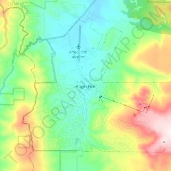
Nombre: Mapa topográfico Angel Fire, altitud, relieve.
Altitud media: 2.786 m
Altitud mínima: 2.526 m
Altitud máxima: 3.361 m
Haz una donación
Otros mapas topográficos
Haga clic en un mapa para ver su topografía, su altitud y su relieve.