
Haz una donación
Mapa topográfico Ruth
Haga clic en el mapa para ver la altitud.
Haz una donación
Ruth
Ruth is a census-designated place (CDP) in Trinity County, California.[2] Ruth is located in the southern portion of the county. The community - and adjacent Ruth Lake - was named after Ruth McKnight, daughter of settlers. The ZIP code is 95526.[3] The community is inside area code 707. It is located near the headwaters of the Mad River (California) and adjacent to the Yolla Bolly-Middle Eel Wilderness. Ruth sits at an elevation of 2,933 feet (894 m).[2] Its population is 254 as of the 2020 census, up from 195 from the 2010 census.
Haz una donación
Acerca de este mapa
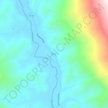
Nombre: Mapa topográfico Ruth, altitud, relieve.
Lugar: Ruth, Trinity County, California, United States (40.24959 -123.34141 40.28959 -123.30141)
Altitud media: 996 m
Altitud mínima: 814 m
Altitud máxima: 1.666 m
Haz una donación
Otros mapas topográficos
Haga clic en un mapa para ver su topografía, su altitud y su relieve.
Whiskeytown-Shasta-Trinity National Recreation Area - Trinity Unit
United States > California > Trinity County
Altitud media: 1.149 m
Haz una donación