
Gracias por apoyar a este sitio ❤️
Haz una donación
Haz una donación
Mapa topográfico Tecopa
Haga clic en el mapa para ver la altitud.
Gracias por apoyar a este sitio ❤️
Haz una donación
Haz una donación
Tecopa
Tecopa (formerly Brownsville[4]) is a census-designated place (CDP) in the Mojave Desert, in Inyo County, California, United States. Tecopa is located 9 miles (14 km) south-southeast of Shoshone,[4] at an elevation of 1,339 feet (408 m).[3] The population was 150 at the 2010 census, up from 99 at the 2000 census.
Gracias por apoyar a este sitio ❤️
Haz una donación
Haz una donación
Acerca de este mapa
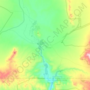
Nombre: Mapa topográfico Tecopa, altitud, relieve.
Lugar: Tecopa, Inyo County, California, United States (35.79330 -116.28677 35.89955 -116.10947)
Altitud media: 508 m
Altitud mínima: 308 m
Altitud máxima: 926 m
Gracias por apoyar a este sitio ❤️
Haz una donación
Haz una donación