
Mapa topográfico Ankeny
Mapa interactivo
Haga clic en el mapa para ver la altitud.
Acerca de este mapa
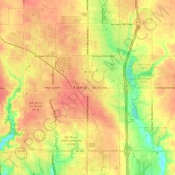
Nombre: Mapa topográfico Ankeny, altitud, relieve.
Lugar: Ankeny, Polk County, Iowa, 50023-3054, United States (41.69187 -93.64038 41.77187 -93.56038)
Altitud media: 289 m
Altitud mínima: 255 m
Altitud máxima: 307 m
Like most of Polk County, Ankeny exists at the bottom area of the Des Moines Lobe, a topographical landscape area, in an area known as the Bemis Advance. The Lobe was formed during the Wisconsin glaciation leaving significant deposits resulting in an area with low relief.