Haz una donación
Mapa topográfico Stone
Haga clic en el mapa para ver la altitud.
Haz una donación
Acerca de este mapa
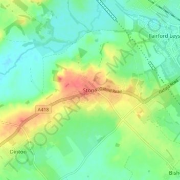
Nombre: Mapa topográfico Stone, altitud, relieve.
Lugar: Stone, Buckinghamshire, England, HP17 8RR, United Kingdom (51.78427 -0.88713 51.82427 -0.84713)
Altitud media: 85 m
Altitud mínima: 66 m
Altitud máxima: 118 m
Haz una donación
Otros mapas topográficos
Haga clic en un mapa para ver su topografía, su altitud y su relieve.
Chilterns National Landscape
United Kingdom > England > Buckinghamshire
The highest point is at 267 m (876 ft.) above sea level at Haddington Hill near Wendover in Buckinghamshire; a stone monument marks the summit. The nearby Ivinghoe Beacon is a more prominent hill, although its altitude is only 249 m (817 ft.). It is the starting point of the Icknield Way Path and the Ridgeway…
Altitud media: 102 m
Haz una donación
Haz una donación
Haz una donación
Aylesbury
United Kingdom > England > Buckinghamshire
Aylesbury is immediately southeast of the upper River Thame that flows past Thame to Dorchester on Thames and is partly sited on the two northernmost outcrops of Portland stone in England bisected by a small stream, Bear Brook which gives a relatively prominent position in relation to the terrain of all near,…
Altitud media: 85 m
Haz una donación
Haz una donación
Chilterns National Landscape
United Kingdom > England > Buckinghamshire
The highest point is 267 m (876 ft.) above sea level at Haddington Hill near Wendover in Buckinghamshire; a stone monument marks the summit. The nearby Ivinghoe Beacon is a more prominent hill, although its altitude is only 249 m (817 ft.). It is the starting point of the Icknield Way Path and the Ridgeway…
Altitud media: 102 m
Haz una donación
Haz una donación
Haz una donación
Haz una donación
Haz una donación
Haz una donación
Haz una donación
Aylesbury
United Kingdom > England > Buckinghamshire
Aylesbury is immediately southeast of the upper River Thame that flows past Thame to Dorchester on Thames and is partly sited on the two northernmost outcrops of Portland stone in England bisected by a small stream, Bear Brook which gives a relatively prominent position in relation to the terrain of all near,…
Altitud media: 85 m
Haz una donación
Haz una donación
Haz una donación
Lillingstone Lovell
United Kingdom > England > Buckinghamshire > Lillingstone Dayrell
Altitud media: 116 m
Haz una donación
Haz una donación
Haz una donación
Aylesbury
United Kingdom > England > Buckinghamshire
Aylesbury is immediately southeast of the upper River Thame that flows past Thame to Dorchester on Thames and is partly sited on the two northernmost outcrops of Portland (lime)stone in England bisected by a small stream, Bear Brook which gives a relatively prominent position in relation to the terrain of all…
Altitud media: 85 m
Haz una donación
Haz una donación
Haz una donación
Beaconsfield and Chepping Wye Community Board
United Kingdom > England > Buckinghamshire > Knotty Green
Altitud media: 115 m
Haz una donación
