
Gracias por apoyar a este sitio ❤️
Haz una donación
Haz una donación
Mapa topográfico Nauvoo
Haga clic en el mapa para ver la altitud.
Gracias por apoyar a este sitio ❤️
Haz una donación
Haz una donación
Nauvoo
Because most of the city is well above flood level, Nauvoo has not historically had problems when the Mississippi River has risen. In both the floods of 1993 and 2008, very little damage was sustained within city limits. Topography maps show a unique feature of Nauvoo with main street starting at the edge of the Mississippi River on the south side of town and ending at the Mississippi River's edge on the north.
Gracias por apoyar a este sitio ❤️
Haz una donación
Haz una donación
Acerca de este mapa
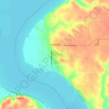
Nombre: Mapa topográfico Nauvoo, altitud, relieve.
Lugar: Nauvoo, Hancock County, Illinois, 62354, United States (40.52304 -91.40685 40.56869 -91.36102)
Altitud media: 178 m
Altitud mínima: 157 m
Altitud máxima: 210 m
Gracias por apoyar a este sitio ❤️
Haz una donación
Haz una donación
Otros mapas topográficos
Haga clic en un mapa para ver su topografía, su altitud y su relieve.