
Haz una donación
Mapa topográfico Dublin
Haga clic en el mapa para ver la altitud.
Haz una donación
Dublin
Located on the Glaciated Allegheny Plateau, Dublin has a relatively flat topography. Nevertheless, there are numerous ravines surrounding the tributaries of the Scioto River, which make for steep cliffs in some areas. Elevations range from 780 feet (240 m) above sea level where the Scioto River leaves the city at Hayden Run Road, while the high point is 1,000 feet (300 m) at Glacier Ridge Metro Park.
Haz una donación
Acerca de este mapa
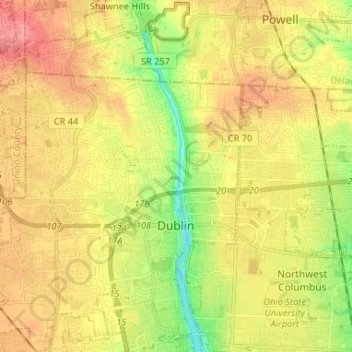
Nombre: Mapa topográfico Dublin, altitud, relieve.
Altitud media: 275 m
Altitud mínima: 231 m
Altitud máxima: 311 m
Haz una donación
Otros mapas topográficos
Haga clic en un mapa para ver su topografía, su altitud y su relieve.
Columbus
United States > Ohio > Franklin County > Columbus
The confluence of the Scioto and Olentangy rivers is just north-west of Downtown Columbus. Several smaller tributaries course through the Columbus metropolitan area, including Alum Creek, Big Walnut Creek, and Darby Creek. Columbus is considered to have relatively flat topography thanks to a large glacier that…
Altitud media: 255 m
Haz una donación
Haz una donación