
Gracias por apoyar a este sitio ❤️
Haz una donación
Haz una donación
Mapa topográfico Tucker
Haga clic en el mapa para ver la altitud.
Gracias por apoyar a este sitio ❤️
Haz una donación
Haz una donación
Tucker
Tucker, at 1,117 feet (340 m) feet above sea level, is the highest point of elevation on the railroad line between Atlanta and Richmond, Virginia.
Gracias por apoyar a este sitio ❤️
Haz una donación
Haz una donación
Acerca de este mapa
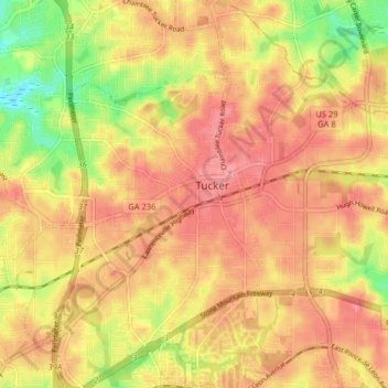
Nombre: Mapa topográfico Tucker, altitud, relieve.
Lugar: Tucker, DeKalb County, Georgia, 30084, United States (33.81841 -84.25263 33.88497 -84.17313)
Altitud media: 317 m
Altitud mínima: 267 m
Altitud máxima: 344 m
Gracias por apoyar a este sitio ❤️
Haz una donación
Haz una donación