
Haz una donación
Mapa topográfico Martha's Vineyard
Haga clic en el mapa para ver la altitud.
Haz una donación
Martha's Vineyard
Martha's Vineyard features a diverse topography characterized by gently rolling hills, sandy beaches, and rugged coastline. The island spans approximately 100 square miles and boasts elevations that reach up to 289 feet at its highest point, offering panoramic views of the surrounding Atlantic Ocean. The terrain is dotted with woodlands, meadows, and wetlands, creating a variety of ecosystems that support a rich array of wildlife. Coastal bluffs and cliffs, particularly along the southern shore, provide dramatic scenery and are shaped by both natural erosion and the forces of the ocean. The island's numerous ponds and inlets add to its scenic beauty, making it a unique blend of maritime and terrestrial landscapes.
Haz una donación
Acerca de este mapa
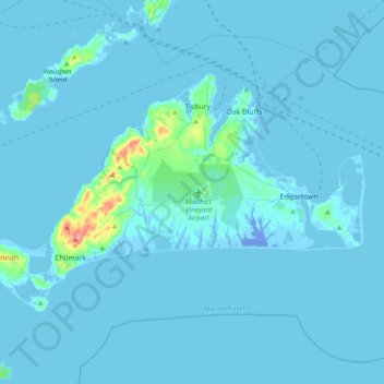
Nombre: Mapa topográfico Martha's Vineyard, altitud, relieve.
Altitud media: 3 m
Altitud mínima: -21 m
Altitud máxima: 85 m
Haz una donación
Otros mapas topográficos
Haga clic en un mapa para ver su topografía, su altitud y su relieve.