
Mapa topográfico Pollachi
Haga clic en el mapa para ver la altitud.
Pollachi
Pollachi is located at 10°39′43″N 77°00′23″E / 10.662°N 77.0065°E / 10.662; 77.0065 near the center of the South Indian Peninsula, surrounded by Western Ghats. It has an average elevation of 293 metres (961 ft) on the banks of Aliyar river. The area is hilly and rocky, drained by several rivers and is thickly forested with some marsh lands and scattered patches of grass. The town receives majority of the rainfall from Southwest monsoon arriving through the Palghat gap and receives an average annual rainfall of around 1,274 mm (50.2 in).
Acerca de este mapa
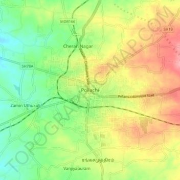
Nombre: Mapa topográfico Pollachi, altitud, relieve.
Lugar: Pollachi, Coimbatore, Tamil Nadu, 642001, India (10.61882 76.96873 10.69882 77.04873)
Altitud media: 289 m
Altitud mínima: 239 m
Altitud máxima: 350 m
Otros mapas topográficos
Haga clic en un mapa para ver su topografía, su altitud y su relieve.