
Mapa topográfico Camberwell
Mapa interactivo
Haga clic en el mapa para ver la altitud.
Acerca de este mapa
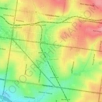
Nombre: Mapa topográfico Camberwell, altitud, relieve.
Altitud media: 66 m
Altitud mínima: 14 m
Altitud máxima: 109 m
The Prospect Hill Road Precinct area is adjacent to the railway station and is the oldest part of the suburb. The original subdivision was relatively generous blocks, which were quickly filled with fine Victorian and Edwardian houses. Due to its hilly topography, many east–west streets in the Prospect Hill area have an excellent view of Melbourne's Central Business District. Its main commercial centre developed along Burke Road from its railway station to Camberwell Junction, 500 m to the south. Several tram routes converge on this point.