
Haz una donación
Mapa topográfico Weldon
Haga clic en el mapa para ver la altitud.
Haz una donación
Weldon
Weldon is a census-designated place (CDP) in Kern County, California, United States. It sits at the southeast tip of Lake Isabella. Weldon is located 9 miles (14 km) east-southeast of Wofford Heights, at an elevation of 2,654 feet (809 m). The population was 2,642 at the 2010 census, up from 2,387 at the 2000 census.
Haz una donación
Acerca de este mapa
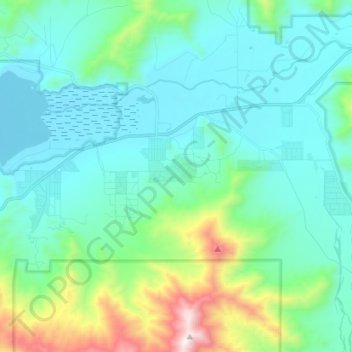
Nombre: Mapa topográfico Weldon, altitud, relieve.
Lugar: Weldon, Kern County, California, 93283, United States (35.60495 -118.38514 35.68207 -118.24307)
Altitud media: 1.030 m
Altitud mínima: 781 m
Altitud máxima: 2.099 m
Haz una donación
Otros mapas topográficos
Haga clic en un mapa para ver su topografía, su altitud y su relieve.
Ford City
United States > California > Kern County > Taft
Ford City is a census-designated place (CDP) in Kern County, California, United States. Ford City is located 1 mile (1.61 km) north of Taft, at an elevation of 892 feet (272 m). The population was 4,348 at the 2020 census, up from 4,278 at the 2010 census. It is immediately north of Taft, between the huge…
Altitud media: 264 m
Haz una donación
South Taft
United States > California > Kern County > Taft > South Taft
South Taft is a census-designated place (CDP) in Kern County, California, United States. South Taft is located 0.5 miles (0.8 km) south of Taft, at an elevation of 1,017 feet (310 m). The population was 2,169 at the 2010 census, up from 1,898 at the time of the 2000 census.
Altitud media: 343 m
Bodfish
United States > California > Kern County
Bodfish is located 32 miles (51 km) east-northeast of Bakersfield, at an elevation of 2,687 feet (819 m).
Altitud media: 924 m
Haz una donación
Weedpatch
United States > California > Kern County
The community, which lies at an elevation of 387 feet (118 m), is situated off State Route 184 (Weedpatch Highway) southeast of Bakersfield, south of Lamont and about 5 miles (8 km) south of State Route 58. It is at 35°14′17″N 118°54′54″W / 35.23806°N 118.91500°W / 35.23806; -118.91500.…
Altitud media: 117 m
Inyokern
United States > California > Kern County
Inyokern (formerly Siding 16 and Magnolia) is a census-designated place (CDP) in Kern County, California, United States. Its name derives from its location near the border between Inyo and Kern Counties. Inyokern is located 8 miles (13 km) west of Ridgecrest, at an elevation of 2,434 feet (742 m). It is on the…
Altitud media: 753 m
Bakersfield
United States > California > Kern County > Bakersfield
Most of Bakersfield’s major streets are six-lane divided roads with bike lanes, with almost every street in the city having proper lane signage for bicycle traffic. Bikes are a popular method of transportation in Bakersfield, due to the city’s relatively flat topography and grid-like street system. Newer…
Altitud media: 161 m
Haz una donación
Taft Heights
United States > California > Kern County > Taft > Taft Heights
Taft Heights (formerly, Boust City) is a census-designated place (CDP) in Kern County, California, United States. Taft Heights is located 1 mile (1.6 km) west-southwest of Taft, at an elevation of 1,178 feet (359 m). The population was 1,949 at the 2010 census, up from 1,865 at the 2000 census.
Altitud media: 368 m
Haz una donación
Sand Canyon
United States > California > Kern County
Sand Canyon is an unincorporated community in Kern County, California. It is located on Cache Creek 7 miles (11 km) east of Tehachapi, at an elevation of 4,500 feet (1,400 m).
Altitud media: 936 m
Twin Oaks
United States > California > Kern County
Twin Oaks is an unincorporated community in Kern County, California. It is located 1.5 miles (2.4 km) east-northeast of Loraine, at an elevation of 2,825 feet (861 m).
Altitud media: 945 m
Haz una donación
Oildale
United States > California > Kern County
Oildale is a census-designated place (CDP) in Kern County, California, United States. Oildale is located 3.5 miles (5.6 km) north-northwest of downtown Bakersfield, at an elevation of 469 feet (143 m). The population was 32,684 at the 2010 census, up from 27,885 at the 2000 census. It is an unincorporated…
Altitud media: 164 m
Haz una donación
Buttonwillow
United States > California > Kern County
Buttonwillow is an unincorporated community and census-designated place in the San Joaquin Valley, in Kern County, California. Buttonwillow is 26 miles (42 km) west of Bakersfield, at an elevation of 269 feet (82 m)). The population was 1,508 at the 2010 census, up from 1,266 at the 2000 census. The center of…
Altitud media: 87 m
Haz una donación
Bealville
United States > California > Kern County
Bealville is an unincorporated community in Kern County, California. It is located on the Union Pacific Railroad (formerly Southern Pacific Railroad) 1.25 miles (2 km) south of Caliente, at an elevation of 1,811 feet (552 m). The area was named after Edward Fitzgerald Beale, who owned the adjacent Rancho El…
Altitud media: 568 m
Wasco
United States > California > Kern County
Wasco (formerly, Dewey and Deweyville) is a city in the San Joaquin Valley, in Kern County, California, United States. Wasco is located 24 miles (39 km) northwest of Bakersfield, at an elevation of 328 feet (100 m). The population was 25,545 at the 2010 census, up from 21,263 at the 2000 census.
Altitud media: 101 m
Johannesburg
United States > California > Kern County
Johannesburg is a census-designated place (CDP) in Kern County, California, in a mining district of the Rand Mountains. Johannesburg is located 1 mile (1.6 km) east-northeast of Randsburg, at an elevation of 3,517 feet (1,072 m). The terminus of the Randsburg Railway was here from 1897 to 1933. The population…
Altitud media: 1.103 m
Maricopa
United States > California > Kern County
Maricopa is a city in Kern County, California. Maricopa is located 6.5 miles (10 km) south-southeast of Taft, at an elevation of 883 feet (269 m). The population was 1,154 at the 2010 census, up from 1,111 at the 2000 census. The Carrizo Plain is located to the northwest, and the enormous Midway-Sunset Oil…
Altitud media: 278 m
Haz una donación
Haz una donación
Woodford
United States > California > Kern County
Woodford is an unincorporated community in Kern County, California. It is located on the railroad 1 mile (1.6 km) southeast of Keene, at an elevation of 2746 feet (837 m).
Altitud media: 899 m
Haz una donación