
Haz una donación
Mapa topográfico Maloneys Flat
Haga clic en el mapa para ver la altitud.
Haz una donación
Acerca de este mapa
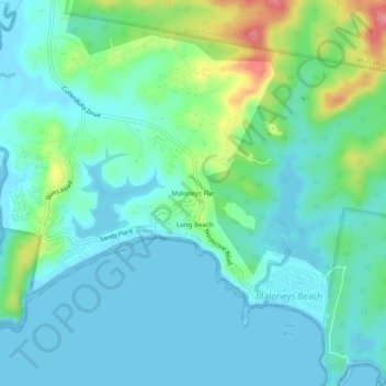
Nombre: Mapa topográfico Maloneys Flat, altitud, relieve.
Altitud media: 24 m
Altitud mínima: -3 m
Altitud máxima: 106 m
Haz una donación
Otros mapas topográficos
Haga clic en un mapa para ver su topografía, su altitud y su relieve.
Sydney
Sydney's topography is characterized by a diverse landscape that seamlessly blends coastal features with inland plateaus. The city is divided into two primary regions: the relatively flat Cumberland Plain to the south and west of Sydney Harbour, and the elevated Hornsby Plateau to the north. The Cumberland…
Altitud media: 53 m
Haz una donación
Haz una donación
Byron Bay
Byron Bay, located in northeastern New South Wales, Australia, is characterized by diverse topography shaped by its geological history. The town is part of the erosion caldera of the ancient Tweed Volcano, which erupted approximately 23 million years ago, resulting in the rich volcanic soils that define the…
Altitud media: 7 m
Haz una donación
Penrith
Australia > New South Wales > Penrith
Penrith is a city in New South Wales, Australia, located in Greater Western Sydney, 55 kilometres (31 mi) west of the Sydney central business district on the banks of the Nepean River, on the outskirts of the Cumberland Plain. Its elevation is 32 metres (105 ft).
Altitud media: 34 m
Haz una donación
Haz una donación
Haz una donación
Mount Warrigal
The suburb includes "Native Dog Hill" and its surrounding areas. To the north and west are the shores of Lake Illawarra. With its high elevation above the surrounding areas and close proximity to the lake, the suburb has excellent views of the Pacific Ocean to the east, Lake Illawarra and the Illawarra…
Altitud media: 12 m
Haz una donación
Goulburn
Owing to its elevation, Goulburn has an oceanic climate (Cfb) with warm summers and cool winters; with a high diurnal range. Its climate is variable much of the year, though generally dry with maximum temperatures ranging from 11.8 °C (53.2 °F) in July to 28.3 °C (82.9 °F) in January. Rainfall is…
Altitud media: 666 m
Haz una donación
Haz una donación
Haz una donación
Haz una donación
Orange
Orange is a city in the Central Tablelands region of New South Wales, Australia. It is 254 km (158 mi) west of the state capital, Sydney [206 km (128 mi) on a great circle], at an altitude of 862 metres (2,828 ft). Orange had an estimated urban population of 40,493 as of June 2018 making the city a significant…
Altitud media: 852 m
Haz una donación
Haz una donación
Haz una donación
Haz una donación
Haz una donación
Lane Cove National Park
Australia > New South Wales > Sydney
The park includes areas of land which are part of Ku-ring-gai, Ryde, and Hornsby local government areas with small areas of the park in Willoughby, Lane Cove and Hunter's Hill local government areas on the banks of the lower reaches of the river. The park is surrounded on all sides by developed suburban areas…
Altitud media: 81 m
Haz una donación
Bilgola Plateau
The suburb is mainly residential, with two small rows of shops, a small park and a primary school located on the top of the plateau. Bilgola Beach on the eastern side features a surf club and kiosk. Rising to an elevation of 150m above sea level, the suburb has views of the beach and the ocean on the eastern…
Altitud media: 37 m
Haz una donación
Haz una donación
Haz una donación
Haz una donación
Yass
Yass is located 280 km south-west of Sydney, on the Hume Highway. The Yass River, which is a tributary of the Murrumbidgee River, flows through the town. Yass is 59 km from Canberra; lying at an elevation of 505 m AMSL.
Altitud media: 533 m
Haz una donación
Paddington
Paddington is a rare and largely intact example of an early Victorian residential suburb. Its unique qualities may be attributed to its close proximity to the city, the topography of its harbour location, the process of development and subdivision of early land grants, and the short period in the late l9thC in…
Altitud media: 42 m
Haz una donación
Haz una donación
Haz una donación