
Haz una donación
Mapa topográfico West Springfield
Haga clic en el mapa para ver la altitud.
Haz una donación
Acerca de este mapa
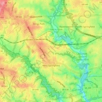
Nombre: Mapa topográfico West Springfield, altitud, relieve.
Altitud media: 86 m
Altitud mínima: 43 m
Altitud máxima: 132 m
Haz una donación
Otros mapas topográficos
Haga clic en un mapa para ver su topografía, su altitud y su relieve.
Haz una donación
George Washington's Mount Vernon
United States > Virginia > Fairfax County > Mount Vernon
Visitors to Mount Vernon now see Washington's study, a room to which in the 18th century only a privileged few were granted entry. This simply furnished room has a combined bathroom, dressing room and office; the room was so private that few contemporary descriptions exist. Its walls are lined with naturally…
Altitud media: 14 m
Izaak Walton League of America - Arlington-Fairfax Chapter
United States > Virginia > Fairfax County > Centreville
Altitud media: 72 m
Haz una donación
Haz una donación
Haz una donación
Mount Vernon Community Park
United States > Virginia > Fairfax County > Fort Hunt > Snowden
Altitud media: 14 m
Haz una donación
Shirley Gate Park
United States > Virginia > Fairfax County > George Mason > Shirley Gate Park
Altitud media: 128 m
Haz una donación