
Mapa topográfico East Merrimack
Mapa interactivo
Haga clic en el mapa para ver la altitud.
Acerca de este mapa
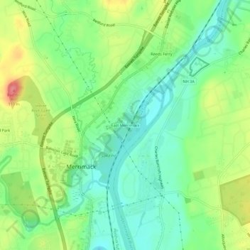
Nombre: Mapa topográfico East Merrimack, altitud, relieve.
Altitud media: 55 m
Altitud mínima: 23 m
Altitud máxima: 107 m
Otros mapas topográficos
Haga clic en un mapa para ver su topografía, su altitud y su relieve.
Reeds Ferry
United States > New Hampshire > Hillsborough County > Merrimack
Reeds Ferry, Merrimack, Hillsborough County, New Hampshire, 03054, United States
Altitud media: 58 m