
Mapa topográfico Hills
Mapa interactivo
Haga clic en el mapa para ver la altitud.
Acerca de este mapa
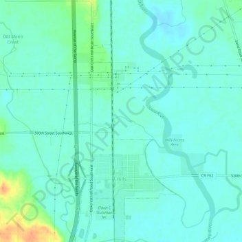
Nombre: Mapa topográfico Hills, altitud, relieve.
Lugar: Hills, Johnson County, Iowa, 52235, United States (41.54368 -91.54509 41.58380 -91.52260)
Altitud media: 196 m
Altitud mínima: 186 m
Altitud máxima: 229 m
Otros mapas topográficos
Haga clic en un mapa para ver su topografía, su altitud y su relieve.
Tiffin
United States > Iowa > Johnson County
Tiffin, Johnson County, Iowa, 52340, United States
Altitud media: 227 m
North Liberty
United States > Iowa > Johnson County
North Liberty, Johnson County, Iowa, 52317, United States
Altitud media: 235 m
Coralville
United States > Iowa > Johnson County
Coralville, Johnson County, Iowa, 52241, United States
Altitud media: 224 m
Iowa City
United States > Iowa > Johnson County > Iowa City
Iowa City, Johnson County, Iowa, 52240-5544, United States
Altitud media: 225 m
Iowa City
United States > Iowa > Johnson County
Iowa City, Johnson County, Iowa, United States
Altitud media: 216 m