
Haz una donación
Mapa topográfico Milton
Haga clic en el mapa para ver la altitud.
Haz una donación
Milton
Massachusett, the indigenous name for the Great Blue Hill, was the largest of the cluster of hills along the southern coast of Massachusetts Bay. As the second-highest elevation in all of Eastern America directly on the Atlantic coast, it possessed a sacred status in the religion of the Massachusett people. Beyond being a sacred site, the various hills were mined extensively by the indigenous inhabitants due to the abundance of a type of rare stone formed by the volcanic eruption of Massachusett 200 million years ago that was highly favorable for stone tools. These tools were traded among the indigenous people of the Northeast due to the rarity of the stone. This also indicates that the trade networks of the indigenous Northeast were far more expansive than previously thought.
Haz una donación
Acerca de este mapa
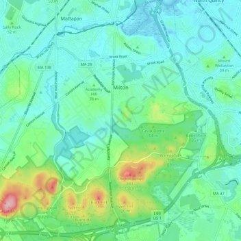
Nombre: Mapa topográfico Milton, altitud, relieve.
Lugar: Milton, Norfolk County, Massachusetts, United States (42.20071 -71.13075 42.27803 -71.03143)
Altitud media: 41 m
Altitud mínima: -2 m
Altitud máxima: 189 m
Haz una donación
Otros mapas topográficos
Haga clic en un mapa para ver su topografía, su altitud y su relieve.
Haz una donación
Haz una donación
Weymouth Woods
United States > Massachusetts > Norfolk County > Weymouth > South Weymouth > Pine Grove
Altitud media: 49 m
Haz una donación
Haz una donación
Lake Massapoag
United States > Massachusetts > Norfolk County > Sharon
Because of the lake and the fact that Sharon is at a slightly higher elevation than the surrounding towns, and because it is located on the main rail line going south from Boston, the shores of the lake developed into a minor summer resort with several large hotels, summer camps and cottage colonies. Temple…
Altitud media: 84 m
Haz una donación
Haz una donación
Haz una donación
Haz una donación
Haz una donación
Haz una donación
Wellesley Farms
United States > Massachusetts > Norfolk County > Wellesley > Wellesley Farms
Altitud media: 48 m
Haz una donación
Haz una donación