
Haz una donación
Mapa topográfico Delicate Arch
Haga clic en el mapa para ver la altitud.
Haz una donación
Delicate Arch
Delicate Arch is one of the main tourist draws in Arches National Park. The parking lot at the Delicate Arch Trailhead, although large, fills up quickly on most days. The trail to Delicate Arch is 3 miles (4.8 kilometer) round trip with an elevation change of 480 feet (146 meters). The trail is well defined for the first 1/2 mile, then does a steep incline over open rock. There is a narrow ledge for the last 200 yards (183 meter) before reaching the arch.
Haz una donación
Acerca de este mapa
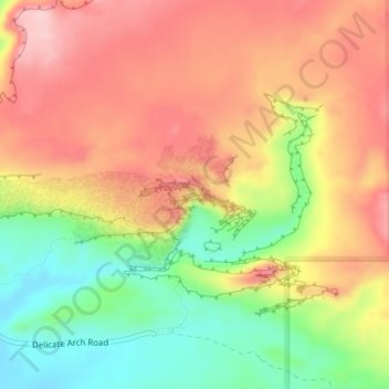
Nombre: Mapa topográfico Delicate Arch, altitud, relieve.
Lugar: Delicate Arch, Grand County, Utah, United States (38.74341 -109.49945 38.74353 -109.49913)
Altitud media: 1.409 m
Altitud mínima: 1.309 m
Altitud máxima: 1.490 m
Haz una donación
Otros mapas topográficos
Haga clic en un mapa para ver su topografía, su altitud y su relieve.