
Mapa topográfico Arak
Mapa interactivo
Haga clic en el mapa para ver la altitud.
Acerca de este mapa
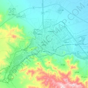
Nombre: Mapa topográfico Arak, altitud, relieve.
Lugar: Arak, بخش مرکزی, Arak County, Markazi Province, Iran (34.04294 49.60821 34.13117 49.79708)
Altitud media: 1.871 m
Altitud mínima: 1.669 m
Altitud máxima: 2.616 m
Arak is surrounded by mountains in the south, west, and east, and its average altitude is about 1750m above sea level. It is located 260 km from the city of Tehran, and is in the vicinity of the cities of Qom and Isfahan.
Otros mapas topográficos
Haga clic en un mapa para ver su topografía, su altitud y su relieve.
Arak
Iran > Markazi Province > Arak County > Arak
Arak, بخش مرکزی, Arak County, Markazi Province, 3814999184, Iran
Altitud media: 1.914 m