
Mapa topográfico Shipton Bellinger
Haga clic en el mapa para ver la altitud.
Acerca de este mapa
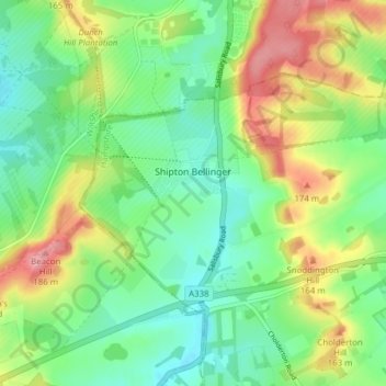
Nombre: Mapa topográfico Shipton Bellinger, altitud, relieve.
Altitud media: 126 m
Altitud mínima: 87 m
Altitud máxima: 191 m
Otros mapas topográficos
Haga clic en un mapa para ver su topografía, su altitud y su relieve.
Bath Meadows
United Kingdom > England > Hampshire > Test Valley > Wellow > East Wellow
Altitud media: 30 m
Charlton Down
United Kingdom > England > Hampshire > Test Valley > Wildhern > Charlton Down
Altitud media: 111 m
Bitterne Grove
United Kingdom > England > Hampshire > Test Valley > Mottisfont > Dunbridge
Altitud media: 39 m
Canada Common
United Kingdom > England > Hampshire > Test Valley > Wellow > Canada
Altitud media: 39 m
The Bog
United Kingdom > England > Hampshire > Test Valley > Braishfield > Crookhill
Altitud media: 39 m
Hazel Wood
United Kingdom > England > Hampshire > Test Valley > Wellow > Wellow Wood
Altitud media: 37 m