
Gracias por apoyar a este sitio ❤️
Haz una donación
Haz una donación
Mapa topográfico Stockton
Haga clic en el mapa para ver la altitud.
Gracias por apoyar a este sitio ❤️
Haz una donación
Haz una donación
Acerca de este mapa
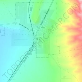
Nombre: Mapa topográfico Stockton, altitud, relieve.
Lugar: Stockton, Tooele County, Utah, 84071, United States (40.43577 -112.38278 40.46142 -112.35307)
Altitud media: 1.580 m
Altitud mínima: 1.512 m
Altitud máxima: 1.732 m
Gracias por apoyar a este sitio ❤️
Haz una donación
Haz una donación
Otros mapas topográficos
Haga clic en un mapa para ver su topografía, su altitud y su relieve.
Deseret Peak
United States > Utah > Tooele County
Deseret Peak is the highest peak in the Stansbury Mountains with an elevation of 11,035 ft. It is located in the Deseret Peak Wilderness area west of Grantsville, Utah and east of Skull Valley Indian Reservation. It is the fourth most topographically prominent peak in the state of Utah. The site is a popular…
Altitud media: 2.910 m
Gracias por apoyar a este sitio ❤️
Haz una donación
Haz una donación