
Mapa topográfico Indore
Haga clic en el mapa para ver la altitud.
Indore
Indore /ɪnˈdɔːr/ (listen) is the most populous and the largest city in the Indian state of Madhya Pradesh. It serves as the headquarters of both Indore District and Indore Division. It is also considered as an education hub of the state and has campuses of both the Indian Institute of Technology and the Indian Institute of Management. Located on the southern edge of Malwa Plateau, at an average altitude of 550 meters (1,800 ft) above sea level, it has the highest elevation among major cities of Central India. The city is 190 km (120 mi) west of the state capital of Bhopal. Indore had a census-estimated 2011 population of 1,994,397 (municipal corporation) and 2,170,295 (urban agglomeration). The city is distributed over a land area of just 530 square kilometres (200 sq mi), making Indore the most densely populated major city in the central province. It comes under Tier 2 cities in India.
Acerca de este mapa
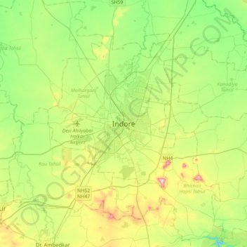
Nombre: Mapa topográfico Indore, altitud, relieve.
Altitud media: 555 m
Altitud mínima: 445 m
Altitud máxima: 775 m
Otros mapas topográficos
Haga clic en un mapa para ver su topografía, su altitud y su relieve.
Siddheshwar Hanuman Mandir Udyaan
India > Madhya Pradesh > Juni Indore Tahsil > Indore
Altitud media: 550 m