
Gracias por apoyar a este sitio ❤️
Haz una donación
Haz una donación
Mapa topográfico Tysonville
Haga clic en el mapa para ver la altitud.
Gracias por apoyar a este sitio ❤️
Haz una donación
Haz una donación
Acerca de este mapa
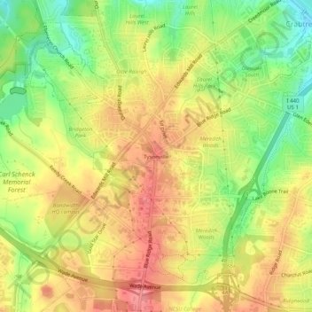
Nombre: Mapa topográfico Tysonville, altitud, relieve.
Altitud media: 118 m
Altitud mínima: 71 m
Altitud máxima: 155 m
Gracias por apoyar a este sitio ❤️
Haz una donación
Haz una donación
Otros mapas topográficos
Haga clic en un mapa para ver su topografía, su altitud y su relieve.
William B. Umstead State Park
United States > North Carolina > Wake County > Raleigh
Umstead is part of the Southeastern mixed forests ecoregion. The topography is hilly, and it has several artificial lakes (which are very common in Wake County, partially due to a flood control plan implemented over the last half-century).
Altitud media: 116 m
Lake Raleigh
United States > North Carolina > Wake County > Raleigh > Isle Forest
Altitud media: 104 m
Gracias por apoyar a este sitio ❤️
Haz una donación
Haz una donación